
NJ AT Hike #6
December 6, 2015 § Leave a comment

Frosted weeds
“Who ever decided on extending this hike to 17A, Fuck You!” Andy was a little grumpy, and he had turned a patch of exposed pink granite gneiss into a Tempurpedic mattress for a short rest, but he was still moving, and in the end he was going to make it.
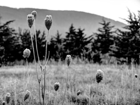
High Contrast frosted weeds
If you followed the last hike, then you are aware that because of a map malfunction we undersized our hike by about 2 miles, and that we had decided on extending our hike into NY because we only had about 15 miles of New Jersey left, and if we extended the hike to NY 17A, that would make two nice hikes of it.

Frosted Field against Wawayanda Mountain
With the goal still set at NY 17A, then we had about 14.5 – 15 miles of hiking to do in a daylight shortened December day. On the plus side, once we gained elevation, we would basically keep that elevation the rest of the hike. That doesn’t mean flat hiking, but it did cut out any deep valley descents and re-ascents on the other side. However, this ridge line is rocky and contains many frequent changes in elevation, and is therefore not an easy hike by any stretch of the imagination. Hence Andy’s aforementioned comment.

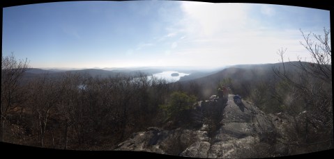
Group Shot overlooking Vernon Valley
Our hiking day began like all our other hiking days. All of our collective alarm clocks awoke us from dreamy slumber somewhere between 4 and 4:30 am. If we all prepared the might before, then everything we need is together already and sitting by the door ready to grab. Personally, I had everything laid out. I knew it was going to be a very cold start, but I elected to go with my Sport Kilt again. To this I included compression undies, compression socks, Smartwool hiking socks, a compression long-sleeved base layer, and a long-sleeved wicking hiking jersey. For head wear I figured my Craft skull cap would be sufficient, and for gloves I grabbed some full fingered cool weather gloves. Though the sun was expected all day, we wouldn’t see it for the ascent of Wawayanda Mountain, nor would we be bathed in it until well into the morning. As a backup plan I included my hoodie sweatshirt for those just in case moments.

Vernon Valley
I decided to keep my fuel supply simple. I would eat some instant oatmeal before I left the house, and I would snack on Honey Stinger waffles, organic dried figs, and Trader Joe’s Dark Chocolate with Almonds. That was it. In hind sight, I was a little low on carbohydrate replacement, and will have to keep that in mind for our next adventures. I brought a 32 oz water container, and then at the last minute added an additional 16 oz. bottle. I packed my water sterilizer, thinking I would simply stop at a stream and replenish.

Frosty Creek Bridge Crossing
My shoes, and poles were in my truck already, so other than grabbing the six pack of Six Point Global Warmer Imperial Red Ale from the refrigerator, I was ready to go. I would drive to our meeting rendezvous, but I would not volunteer to drive further. My brake light had been on for a couple of weeks, and my check engine light had just come on. With my car in the shop, as I write this now, it turns out that my gas tank was being held in place by only one of two straps. The other apparently having corroded away!
Fall Foliage is pretty much all down now.
We had been expecting Susie to join us for this last NJ section hike. She accompanied our first section, which didn’t really end well for her. Towards the end, she was getting tired, and then failed to lift her foot high enough to clear a protruding rock, and tripped thus launching her fully forward in the unrelenting pull of gravity, to the ground. She didn’t make any of the hikes after that, and so it was with some trepidation that we awaited her arrival for this hike. Jed and I had the worries, as we both knew this would be a strenuous hike, and maybe she wouldn’t be up for it.

Crossing one of the quiet streams.
We were ready to leave, and I decided to text Susie to see if she slept in. The reply came back immediately that she was in the parking lot having just arrived and was herself waiting. She was as excited to be going as we were excited that she had made it. We settled the vehicles to be left behind and left for Greenwood Lake, me with Jed, Susie and Mike with Andy.
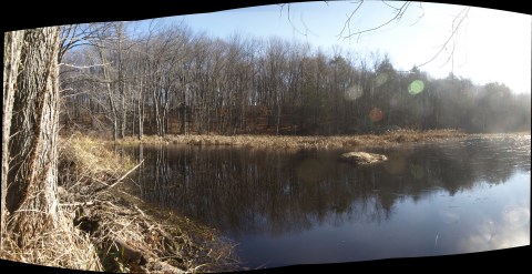
Wawayanda Pond
The drive was uneventful. Jed yielded directions from what Google Maps said was the best route to what I said was the route to take. The GM route seemed interesting, but I had never gone that way before, and I just didn’t feel like this was the time to try something new. Parkway to 17 to 287 to 87 to 17 to 17A past the NY Renaissance Fair location in Sterling Forest, up and over Warwick Mountain and through Upper Greenwood Lake. We dropped off Andy’s car where we left our comfy shoes and the six-pack and shuttled to Vernon Valley. It was the straightest shuttle of all our AT shuttling adventures. 17A to 94 and then don’t miss the trail parking. Andy drove right past it, and after turning around, almost drove past it again!

Susie’s View of Mike
Ready to hike we set out. With Wawayanda Mountain to the East of us, we would not see the sun until We at least got over it. A thick coating of Frost settled upon Vernon Valley and gave the landscape a very antiquey black and white picture feel. Post processing photos to remove color, didn’t actually have to work all that hard! The trail sets off directly for the mountain, which appears ahead as a wall. At the last minute, a Southern turn marks the beginning of the ascent through a boulder field. The trail angles up the mountain continuously, switch-backing near the top to gain access to a marvelous mountain vista of Vernon Valley. During our ascent, we were passed by a couple of runners navigating the rocky trail in running shoes. Strange we thought this was, however upon gaining the vista, it was clear that was their target, and was probably a weekly target, or even an every other day target as their favorite running destination. The view must be for them, the same comfort feeling I get when I do my bread-and-butter Sandy Hook ride in the early morning.

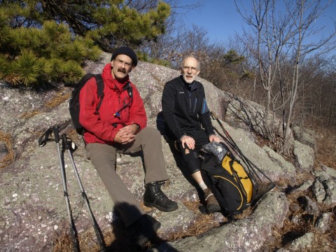
Andy on one of our breaks
Jed and I had already shed clothing during the ascent, but were already starting to chill again before Susie and Andy arrived. Mike arrived with us, but neither did he shed clothing, nor did he add any more. He appeared to be pretty well bundled up, but as I learned later, underneath his shell, he wasn’t wearing much. Just a couple of layers on his upper torso. Susie arrived at the top in a sleeveless top, so she must have had some metabolism functioning fairly well. Andy sweats worse than cold pipes in a steam room, so was down to a fleece layer over a wicking base layer. Jed was functioning well with fleece and hiking pants, under which he had his standard elastic knee brace.

Upper Elevation Marsh
Wawayanda Vista seemed an excellent group photo shot. I brought my compact tripod, and setup the shot. I set the timer, depressed the shutter release, and just at the moment I was set to dash into the picture, I realized that the camera was still attached to my pack via the safety line. That line is not easy to disengage, and even with the 12 second delay, the first shot snapped as I was halfway to my place. I reset the timer, and we took two more shots. I had to post-process this shot, because we were all in shadow, and idiot me didn’t set the flash. Ugghh! How does someone who is raised in the photography business, forget to set the flash?!?
Mike and Jed looking up when I asked them to.
We eventually arrived at Barrett Road, which with proper maps, would have been our starting point today. The past is the past, and today, Barrett Road was simply a road crossing. There would not be many road crossings today. In fact there may only have been two paved roads, and at most two unpaved. We will not count abandoned woods roads which even those numbered a couple.

Near the NJ/NY State Line
Before long we were within the boundaries of Wawayanda State Park, and glaring into the sun across Wawayanda Pond. Everything Wawayanda now!. It was at this point I started to feel that the trail might have been re-routed further south of when Mike and I hiked back in 96. From what I recall on that trip, we came to a trail junction with the access spur to the Wawayanda Shelter off to the South. Today, the access spur to the shelter was off to the North. Before we arrived at the spur, it was clear, both to the eyes and the ears that there was a fairly large group camped in the woods the previous night. They were breaking down camp and were rather loud and boisterous. It wasn’t until we hit the spur to the shelter that it became apparent that they were all camping around the shelter. They had all walked in from the main parking area about a mile away. A giant of a man had a four-wheeled wagon loaded with stuff that he was getting ready to haul out of the woods. It looked like they were all cleaning up, and that all the beer they brought in had been consumed.

It would seem the old ladder has been replaced.
There is a common feeling that goes around when a challenging goal is set, and the achievement of that goal is put to the test. As mileage count increases, so too do the weight of your boots, and more significantly the clearance level between the bottom of your boot and the top of anything that could cause you to trip decreases. With this in mind, it is not uncommon to hear the familiar sound of a boot kicking a protruding stone followed by a couple of quick mis-steps required for balance recovery. Mike, Jed and I had been pretty consistently the lead 3, not necessarily in that order, so I can only speak for these boot sounds among ourselves. What was happening behind us with Andy and Susie, they will have to speak to, however Andy’s face tells all when they catch up during a rest break.

Andy can fall asleep on anything including 100 million year old pink granite.
When the trail finally reaches it’s South Easternmost point (NJ) and hangs a 90 to the Northeast, thus begins the second half of the day’s adventure and except for the initial climb up a, the most strenuous part of the hike lay ahead. I feel it is fair to mention that this section contains 3 distinct types of terrain. I alluded to pink granite earlier, however upon further research, the highlands area surrounding Greenwood Lake, and much of Orange County, NY is Gneiss. To be more specific it is Granite Gneiss, though the transformation to Granite Gneiss can be of either Igneous or sedimentary origins. Based on my recollections, the definitions of Granite Gneiss ring truer with my observations of the rock along this ridge. It is exposed on the surface along much of the ridge which leads to one of the terrains I alluded to. Long expanses of exposed edge on Gneiss that provides excellent gripping power and is fairly easy to walk upon. It may be flat, or have an incline positive or negative, but it is fairly easy to put one foot in front of the other and proceed.

Selfie Stick Behind Me Shot
On the surface, the sections are disconnected which brings us to the second kind of terrain. There are saddles between the exposed sections, and these tend to be fairly strenuous, either in gaining elevation or conceding it. The saddle is usually well treed, and there may be a small stream to cross, but the way through is by no means a trail which your feet will always find an unimpeded trail, and thus with heavy feet this is a section where the thumping of boots can be heard.
Greenwood Lake
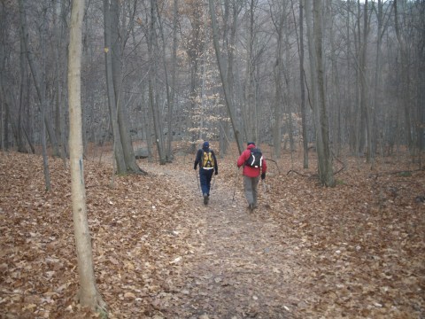
The final terrain type is the woods trail, which after the main part of this ridge section greets the weary hiker as the trail descends to the saddle in the ridge through which 17A passes. This is where the hiker can set the eyes fairly firmly ahead of them and observe the surrounding forest with little thought to what lies beneath the leaves. The mechanics of the stride still need to be heel-to-toe, heel-to-toe, so that should something present itself, the heel is supporting the full transition weight, and the likelihood of a sudden twist to the ankle is minimized.

Exposed Granite Gneiss
This is a wonderful section of the AT for a day hike. An out and back from 17A if no shuttle is available, or an out and back from The State Line Trail head along Route 511 on the Western Shore of Greenwood Lake. If a shuttle is available, then State Line to 17A is an excellent excursion. If you have the legs, the shuttle and the time, then why not Vernon Valley to 17A. If you do it in the Summer Months, then Bellvale Farms Creamery ice cream can be your goals end and not just a six pack of good craft ale.
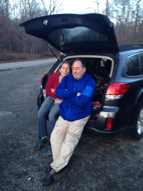
Relaxing at the end

Bliss

Leave a comment