
Christmas AT Backpacking Trip – Ma to NY via CT – A Change of Plans
January 5, 2020 § 1 Comment
You may recall from an earlier post, the preparation and the plans I made for this grand winter adventure. As is usual I fall into a capabilities trap. I reason (wrongly) that if I can cover 6 miles in Hartshorne Woods in 90 minutes, then surely I can cover 21.6 miles in 7.5 hours of daylight. The math says 18 miles in 4.5 hours, which leaves 3 hours to spare for the final 3.6 and some stopping here and there, and that is where my fatal flaw lies. An unburdened jaunt through Hartshorne, is not the same as a burdened, though lightly burdened I was, jaunt through the Taconic Mountain range through which most of the Connecticut AT traverses. You just can’t do it. Let me re-phrase. A 60 year old in decent shape such as myself coot still can’t do that. Hell, the same flaw led us to a 21 mile hike in June along the AT where we still didn’t cover our goal, and we had a much longer day for that.
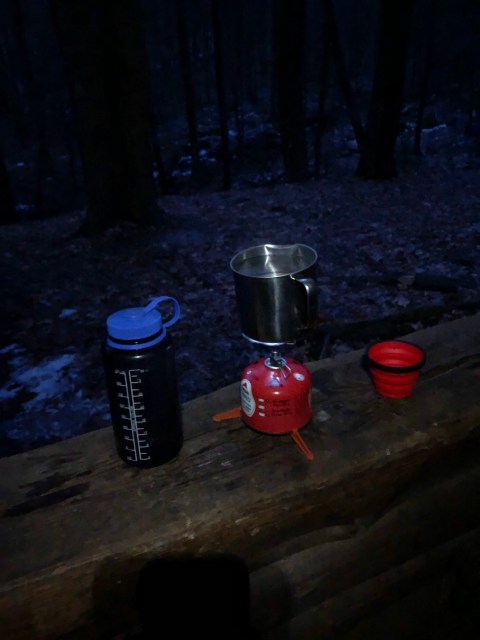
When I last wrote of this trip, I hike 1.5 hours at night and descended a somewhat treacherous blue blazed trail to reach the Lime Spring Shelter, so named for Lime Spring which emerged from the ridge just behind the shelter. Awake at 5:30 in the am I was not, and so I lost one opportunity to get the most out of the day by not getting up until 7. It was not long before I had the other half of my non-treated water boiling, and since this was supposed to be a long day, I decided today was a breakfast hash day, and I re-hydrated the package with eggs, ham, and potatoes. A double of Starbucks Via and Spanish Espresso and I was soon warming my innards with black coffee and hash. Everything packed up easily, I drank the rest of my treated water, took care of some business between myself and the privy and I was out the front opening before 8:15. I could have been on the trail for 90 minutes already, but I was just getting started, and I had to hike half a mile just to get back to the trail, from which the next shelter junction was 11.1 miles south.


At this point I had no idea what the day had in store for me. My legs, though not fresh, did feel a bit refreshed and I started off well. What lay ahead? I would walk this ridge for a bit, then descend down to and intersect The Housatonic River. The trail crosses to the East side of the river for a short time then recrosses again before ascending the Taconic ridge again. From there the trail bobs up and down in the woods eventually passing Pine Swamp Shelter at 11.1 miles, and then some more bobbing before descending into another ravine for a crossing, then a road, then a little more Taconic ridge, and finally back down to the Housatonic for a few miles before Stewart Hollow would appear. Buried in there were some designated campsites which, not completely unlike Shelter sites, only lacked an actual shelter.
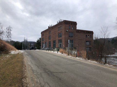
Off I was, and moving along fine. I feel like I reached the Housatonic without any great fanfare or challenges. The first sighting was actually quite an impressive sight. A damn across the river created head for some downstream facility. As I could see, there were outlets that let a certain amount of the river through the structure, and hence the sound, and then it wasn’t until I hiked further downstream and came across the Falls Village generation facility which must be cranking out electricity for a lot of local homes. There was a pretty significant electric field, as in a field with a lot of high voltage electric converters, around which the AT traversed. There was even a shot of an original impeller.


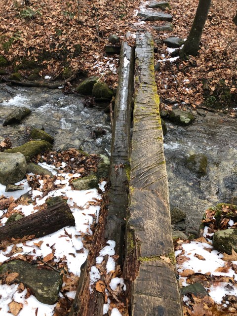
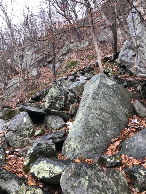
Before long I was across the Hous again, and then it got fun real fast. See, it was time to get back into the Taconic Range, and the trail here didn’t waste any time gaining elevation. In fact, I hit a number of hard-core rock scrambles where I had to negotiate ice, and had to put my poles away, because I needed my hands to pull myself up many of the giant steps. Following the trail here was slow and calculated. Not a pace for cranking out 21 miles. My initial goal here was something called St. John’s Ledge, which did offer a mighty fine view, but I wasn’t on top yet. No, the top was Caleb’s Peak and to get there was more rock scrambling. Pictures don’t do justice to the scramble because the lack of depth, and inability to capture the steepness just leaves the pictures looking “Oh, isn’t that nice. Rocks”.

By the time I reached Pine Swamp Shelter it was close to 2 PM, which meant that if I was to reach Stewart Hollow Shelter, 10 mi, that I was going to be hiking in the dark again. Now let’s be clear. I didn’t want to hike in the dark again, but if, let’s say, I got all the way to the Housatonic again before it got dark, then I could realistically hike that flatish section for the 3 miles to the shelter, but I wasn’t sure I would get even that far. It was at this point, that I retrieved the paper map that came with the guidebook which showed the locations of the various campsites. Ceasar Brook looked like a reasonable reach from my present location. If I stayed there, I could then shoot for Mt Algo Shelter the next night, and that would leave me with a very achievable goal of the state line. From there I could look to Uber, or even hitch a ride to Wingdale and catch the train. My original plan, was officially in the toilet, and I was not going to make it all the way to the AT stop on the Harlem Line.
There is a funny and frustrating thing about the Appalachian Trail, and to understand it, I think we have to understand that the trail is old, in some ways when compared to the forest that is around it. It’s hard to imagine, but much of the forest in New England was logged, and much of what we see today is replanted, and in many cases, non-native. But if you imagine a harvested ridge, then you can imagine that, as trail designers, why wouldn’t you take hikers to the top. There must have been vistas galore on the AT back in the day. Today?? Like I said, the forest is young, and there are a lot of ascents to the top that go unrewarded. And let’s be clear, that is a statement coming from someone who was hiking those summits in the winter time when there is minimal vegetation. In the summer, you can’t see a damn thing, so it must be so frustrating to know you are always going to the top. I was frustrated. The first day was an exception when compared to the rest of the journey. There were some places with some kind of view, but the wide open expanse of vista just was not in the cards.
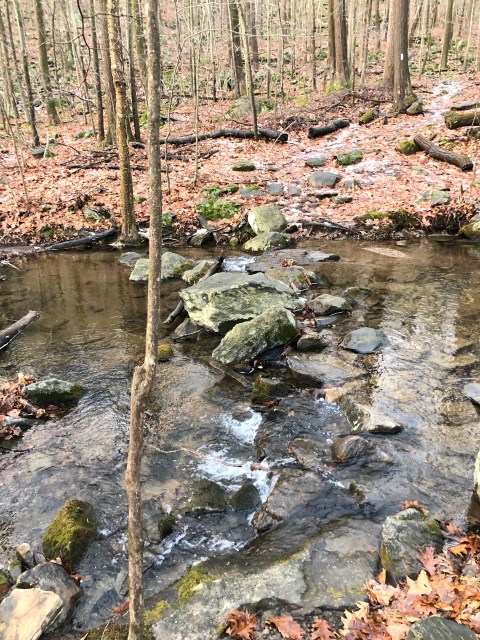
Push on I did, and every descent I made I was convinced “This is the descent to Ceasar Brook”, and though a brook was reached, it was not until that descent was made in the near waning moments of a setting sun did Ceasar Brook finally present itself. Ceasar Brook was a fine brook, and the campsite was mine. Now, let me let you in on what I was thinking in the miles leading to Ceasar. I was thinking how most of the privies I had seen so far were substantial structures built so that two stalls could exist. It was winter so everything in the pit was frozen. So, why not simply set myself up in the privy? If it didn’t stink, and the floor was clean, why not? It’s a flat surface. I could eat my meals outside at the picnic table, but sleeping in the privy vs sleeping on the ground? I’ll take the privy.
Bad news. The privy at Ceasar was simply a box with a toilet seat and an incredible view of the forest around. If it rained, it would be wet business using it, so my thoughts were all for naught. I settled in and decided quickly that based on the number of rocks I saw lying about, that I could use them to secure my tarp. I failed to bring both a ground cloth, and tent spikes, so rocks were needed. I use my hiking poles to support the ridge line of the tarp. Soon, I had a setup, and it was time to eat. I did pack a chair, however when I laid my ass in that chair the first time I wasn’t prepared for the fact that I couldn’t really set my ass into it just right, and in fact I plopped down the final few inches with enough force to cause a rotation over the rear legs, and soon I was flat on my back looking up and thankful there wasn’t a hazard there. I either laughed, or I swore, or perhaps I did both, and reset myself, and learned how to place my ass in the chair without inducing a rotation. Again, I had my two nalgene bottles filled from the stream, one for heating water, and the other to sterilize. Tonight was the peachy chicken.
I was setup before it got dark, and temperature-wise it was above freezing. My tarp was setup in a flat area, and though not soggy, the ground beneath was wet. Without the ground cloth it meant that all my stuff would simply be sitting on the wet ground. My sleeping pad kept my sleeping bag off the wet, but that didn’t mean my bag didn’t get a little wet. When dinner was done, I followed the same routine as the previous night and put everything in the bear box. I wore my booties around camp, which though comfortable, the more I wore them, the more moisture they absorbed. I would find later in the evening as I extracted myself five times to take care of business, just what a pain in the ass it is to put wet booties on your feet. That is how the night went. This evening I was in bed before 6PM. What was there to do?


The day was done, my plans were changed. I had hiked about 17 miles that day, 18.5 the day prior, and I had another 17 day tomorrow, followed by 15 to finish. The trip was working out.

[…] and knocked out the Connecticut portion of the Appalachian Trail. You can read about that here and here, and maybe even here, however in preparation for that trip, I purchased the AMC guide book for that […]