
The Devil’s Path
July 15, 2017 § 2 Comments
If you type “The Devil’s Path” into google the summaries in the top hits read like the following:
- The Devil’s Path is a hiking trail in the Greene County section of the Catskill Mountains of New York, often described as one of the more challenging trails in the … (wikipedia)
- Frequently called the most dangerous and toughest hike in the East, most hikers tackle this trail east to west in order to go up the steepest parts. You’ll bag five … (hikingproject.com)
- The Catskills’ Devil’s Path got its name for a reason. (newyorkupstate.com)
- Devil’s Path Trail is a 21.8 mile heavily trafficked point-to-point trail located near Hunter, New York that features beautiful wild flowers and is… (alltrails.com)
- How to prepare for The Devil’s Path in the Catskills in New York – the toughest trail in the Northeast. (thetrek.co)
Almost all of those are enough to click through on and read more. I am intrigued by the last one in this list, as I am sure I didn’t do anything to prepare for this hike any differently than I would prepare for any hike, or for that matter any local hike here in Monmouth County NJ where the longest steepest climb is neither long, nor steep and exists in Hartshorne Park.
I followed through on the last link to see if it jived with what I thought it might say, but it turns out this link is about what to bring/wear preparedness rather than what to do preparedness. Really there should be a heavily hit link that floats to the top of the search results about what you should physically do to prepare for this hike.
My preparations weren’t that different from my normal routine. For me, normal is 130-170 miles a week on the bicycle riding with friends that includes two hammer sessions, and Wednesday night Track night. If I can get out into Hartshorne once a week, I feel lucky, so the take away here, is that stamina/heart wise, I was very prepared for this hike, and actual hiking wise, almost unprepared. Let me explain what you may already be aware of. There are two components to hiking: ascending and descending. Leaving out level walking, ascending is a hamstring-based operation and descending is quad-based. And the cycling actions favor ascending, so with my stamina, and strong climbing skills I can ascend for long periods of time at a steady rate without rest, and I can recover quickly. Descending is a different cup of tea. At 220 pounds the amount of work the quads have to do to keep the rest of me from falling forward is significant, and it raises the lactic acid level to a point where it isn’t enough for muscle failure, but if you don’t stop often and let it flush, well, then there is an accumulation effect that damages the muscle tissue and there is a price to pay for that.
That price is an inflammation that makes it very difficult to walk in only a few days time. I was pretty lucky on this trip. I started the hike with an anti-inflammatory, and I took more when I finished the first day. I followed that with another 600mg dose the next morning, so I actually felt pretty decent doing the second half of the trail the next day. It’s how I feel right now, two days later, where I clearly understand that I did not prepare properly for this trip.
If you want to do The Devil’s Path, then you need to hike. Not only do you need to hike, but you need give your quads a workout so that they get familiar with the levels of lactic acid that they will have to process. You need to stay as hydrated as possible so that your body operates as efficiently as a properly hydrated body can operate.
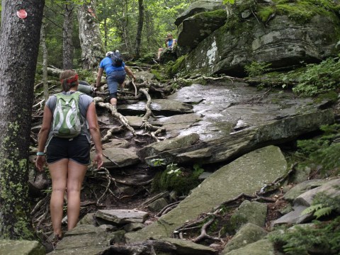
I started with that conclusion because when you read the other links, the text components that stick out the most are the ones that say things like “The hardest”, “The most rugged”, “The most dangerous and hardest”, “The steepest”, “The densest elevation changes”. The Eastern half of this trail is packed solid with challenging and grueling sections of climbs/descents. East to West takes you up the steepest climbs, but that doesn’t mean you don’t have some steep descents, however, I am glad that we hiked the direction we did. The Eastern half will kick your ass.
What should you do if you are planning this trail? That is going to depend on who you are, what your body type is, and maybe how old you are. A late 50’s tall 220 pound male like myself, in decent shape should plan on two days, and should carry a bare minimum. I did not carry a minimum, but if I did it again, I would pare down a little more. I could have carried less water, but that decision is hard to make unless you really know the conditions of the trail. This year it’s been a pretty wet Spring/Summer, and it did rain the night before we started. That said, there were two places on the Eastern section where water could be collected, so I could have gotten away with 1 liter. The Western half had three very reliable sources, and I could definitely get by with 1 liter. So that means I could have started with 1.5 liters less. To be clear, what I am suggesting here is collecting and treating water along the way. Personally I utilize a Steripen, but you can choose your own water treatment method.
I have myself convinced that full leather hiking boots is what I have to wear, but those weigh in at about 4-5 pounds, whereas some lightweight trail runners weigh in at 300 grams. It could be that with the sole of a trail runner, there is less of a sole to roll on, and so the need for the high top is only needed because the height of the sole makes me more likely to roll. That is something I will have to test out, but I did say already that I am in my late 50’s, so how much time do I really have to change things up?
We car-camped at Devil’s Tombstone along Route 214 which is right there where the trail crosses. So as a two day hike, we only carried what we needed to drink and eat, and I carried an SLR, a tripod, the first aid kit, and some other items which added additional weight. If I was backpacking, I think I would break the trip into 3 sections just to limit each day’s total amount of descending. I would recommend:
- Day 1 Predinger Road Trailhead to the shelter between Sugarloaf and Plateau.
- Day 2 Either the shelter on Hunter, or the one just past the Hunter side trail
- Day 3 Complete the hike to the Western trailhead.
How did I end up on this hike in the first place? It all stems from an IM storm that hit my phone after I finished a day hike on Skunemunk Mountain just north of Woodbury, NY. I usually turn my Cellular Data off, or go into full Airplane Mode when I will be out all day, and my phone was in this state while there was a lot of IM chatter on group IM that we had used for a recent barbecue event hosted by Robert DeMulemeester. What I gleaned from the IM stream was there was some discussion about a hike, and when this group of individuals gets to discussing anything, I have to turn the sound off on my phone, because it is just ring-a-ling-ding-a-damn-ding-dong-dang, and I can’t take it.
I asked timidly what they were talking about, and that is how I got included into the discussions of doing The Devil’s Path. The main protagonist for doing this was one Kalyan Ghosh, who weighs less than my new bantam chicken Little Nell, and is an ultra-marathoner. Kal has “Big” dreams of adventures he’d like to do, and this time he had the ear of a bunch of chatty IronMen and IronWomen, and it appeared that people were in, and this was going to happen, and while many of these folks were hardcore triathlete IronPeople, most were not hikers per say, though Kal, I said was a trail runner, and he did get Stephen to do The Escarpment Trail already. This was happening and when I asked about, I was invited along because, well, I am the experienced one with back country outings, and perhaps I might have something to bring to the table of discussions.
I won’t drone on about this, but over the course of many days we hammered out that we were “hiking” and not “backpacking”, and we were doing “two” days, and not a “single” day traverse, and we would “camp” at the halfway point, and not get a motel/hotel. We argued about food a lot, and we settled on doing both dehydrated meals AND salmon, which would be supplemented with Chickpea Salad (Yum), and Sweet Potatoes (Didn’t know we had these). Breakfast was up to everyone to make for themselves, and what you ate along the trail was up to each individual.
We set up a Facegag event page, and we used that and Facegag messenger to communicate, and through this everyone that went came with the correct supplies for a weekend car camping and hiking adventure. We had two tents: one for Stacy and Bob, and another for everyone else. I chose to bring my hammock and if the weather supported it, I would simply sleep in that, but the tent was there if I needed it. Kal brought a single burner canister stove, and I, my pocket rocket isopropane stove to boil water.
While there were many who participated in the discussions, we settled down to 5 people: Stacy, Bob, Kal, Stephen and myself. We met at Exit 109 of the Garden State Parkway where we consolidated into two vehicles, and at 5am we drove the 2 and half hours to the campsite, and transferred all the camping shit to my truck, and all the hiking shit to the van and we set off for the Predinger Road Trailhead. One characteristic that we observed in Stephen was that he was limping. “Why are you limping Stephen?” we asked. “Well, I was running on the track this Wednesday past, and this youngster kind of challenged me to a sprint, and I thought that at 63, I could kick that squirts ass, so I gunned it. Turns out that tough as I am, sprinting is something I should have left in my past, and I pulled my hamstring.” So, we were setting out to do “The Toughest Hike on the East Coast” with a bad hamstring.
Stephen has done 140.6 full Ironman competitions in his lifetime. The first one, he got his mother to run it for him while he was still in the womb. This is one tough mother, and if there was anyone who was going to fight through the pain of some silly pulled hamstring, it was Stephen. Stephen was so tough, that he wasn’t even going to wrap the damn thing! We were less than a mile in, and the whole wrapping thing occurred to me, so I asked him “Did you bring anything to wrap that?”. As it turns out the answer was yes, so “Why the fuck is that bandage not on your leg?”. I embellish here. We stopped, he twisted to find a spot to wrap, and just that awkward turn sent his leg into spasm. I thought “That’s it! He’s done!”, but once the spasm subsided, this tough man hobbled over to a rock and wrapped his leg like it was an Easter Roast, and other than a couple more spasm episodes, he made it. Fucking eh. Awesome.
Robert/Bob took on this hike with an unexpected “Let’s see what this hiking thing is all about?” can do attitude. Bob, has bionic legs, constructed from unobtanium and installed by the leading unobtanium orthopedic surgeon Gerry Goldberger. “You can ski mountains on Mars with these new knees! Just don’t hike in humid moss covered rocky environs and you should be fine.” Of course, The Devil’s Path is cut into the most humid, the most mossiest, the most Pennsylanian Blue Stoniest Oak Tree and pre-historic ferniest environs on the east coast, and though I didn’t hear Bob complain once on the trip, it was clear the trail was taking a toll on him.
What can you say about the Russian Bear Stacy? Stacy actually turned out to be a pretty decent hiker. I thought that other than the fact that when she opened her mouth, “I’m done!” statements dribbled out down her chin, if she had had hiking poles, I think she would have fared the best of all of us. Like myself, she handled the ascents better than the descents, and when it came to portions that tested your ability to move without fear of the drop off that was just inches from your feet, that was really her only weakness. I am not handing out grades, but I would give her a B+/A-. She should hike more, but that said, this trail had lots of features to keep your attention, and as most hikers know, a lot of trails, you simply have to appreciate the quiet solitude of the woods, because not all hikes are like The Devil’s Path. Fortunately for Stacy, we have lots of less challenging, but still exciting trails in the greater NY metro area.
Kal. Kal is an interesting human being. Born in Calcutta, and married to a beautiful Chinese woman with origins in Taiwan, Kal is not like the nearly 100% of most South-Asian Indian continental plate slamming into Asia born individuals that I know or have known. To be fair to all the other 1.2 billion individuals from India that I don’t know, my sample set is somewhat limited, but still I only know one other that rides a bike, and other than Cricket or Tennis, I don’t know a single one that cultivated any athletic aspirations. Anywho, Kal wants to push himself, and he likes a challenge no matter how much out of his comfort zone that challenge lies. He wants to climb K2! Not that tourist trap Everest, but Kfucking2. Since I know Kal is reading this, chew on Alan Arnette’s blogs for a while and see if you can’t simply settle into climbing all 38 of the Catskills Peaks over 3500′, or maybe all 46 peaks in the Adirondaks over 4000′. There is also the Presidential Range in New Hampshire. These are real challenges, and quite an accomplishment to achieve, and none of them involve you having to die trying to do them. Pretty sure Sylvia (wife) will eventually hammer his head solidly between two Griswold 12″ cast iron skillets.
Needless to say, that when it came to finishing both days, Stacy, Bob, and Stephen were done with day 2 before they were done with day 1. I knew before we got off the trail the first day, that at the very least, we would shuttle my truck to the end, and Kal and I would finish, and the others would either hang out and enjoy other Catskills features, or they would drive home. What I hadn’t figured on was that Kal was doubtful for the second day. The man for whom gravity doesn’t hold onto like the rest of us, suffered pretty badly the first day, and bite he was chewing was still fully being chewed and he wanted to spit it out! Fortunately the monsoon storming through his frontal lobe cleared enough and he saw a path forward that included finishing the second day with me. We didn’t really cleared that up until the next morning.
Something I should leave out is that during the preceding evening as we were all chowing down and reminiscing about the day, the subject of “showering” came up and car retrieval. I lobbied for next day car retrieval, because 1) it was dark, 2) we were tired, and 3) it was dark and there were no street lights. But the drawing power of a shower, even though that shower was miles away in a sister campground was too much, and Nathan (Not mentioned until now), who was sitting in our camp site when I arrived, and I invited him to stay, offered to drive them to their van. While they were gone, I took that opportunity to sit quietly alone, sip a little more Auchentoshan scotch and enjoy a nice roll-yer-own before quitting the evening and retiring to my hammock. I honestly don’t think I was in it for 2 minutes before I was out cold. According to others, when they returned, the bright headlights were in fully illuminating my reclined dead body, and they even came over and stared at me, and I failed to awake.
I did not fail, however, to hear Kal’s left on alarm clock go off at 3:45 the next morning!
Let’s wrap this up. Showered and clean, Kal wasn’t eager to do the second day, and I think it was only when I said, that I came to do what we set out to do that he reluctantly agreed to accompany me. We dragged our asses that morning, and looking at the long car shuttle distance, and evaluating the fatigue in my legs, I suggested that instead of shuttling the car, let’s just shuttle ourselves, and we’ll do the Western section West to East. That will give us a gradual ascent for the first mile to stretch our legs and get our hiking mojo fully operational again. When we presented hours as our best estimate, the others agreed to hand out and enjoy what was going to be a beautiful Catskills day, and when we finished we would all get some dinner, and then try not to all fall asleep on the drive home. That is what we did, and all I will say about the Western section is that it is not as rugged and abusing as its Eastern twin, but it is still a hard hike, and I enjoyed it very much.
I feel like this is a group that could do something together again, or perhaps even join me when I do something with my other hiking clan. We could all have fun together.
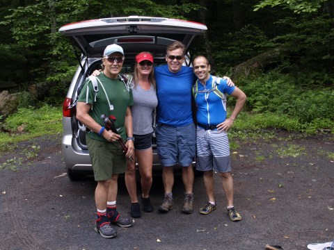
Smiles Galore!!

Kal Demonstrating the climbability of the rock

Green Green Green everywhere.

Bob and Stacy
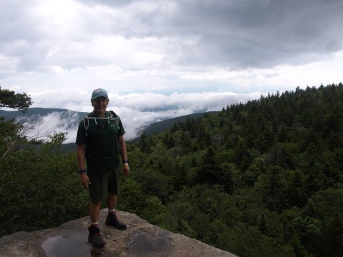
Moi
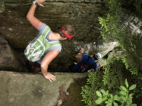
Stacy descending between a gap
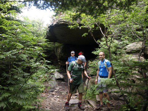

We almost didn’t see that this was the way down.
Another slippery rock ascent
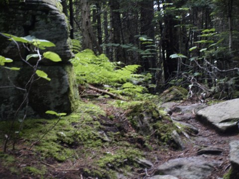
More Emeraldness
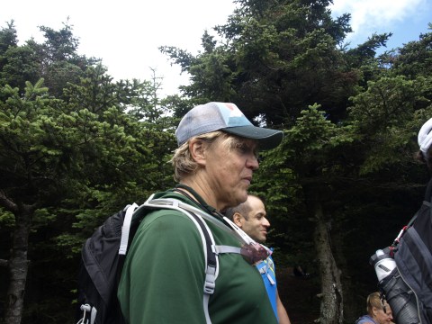
Stephen – 140.6 Ironman Competitions to date!!

Moss and Fungus
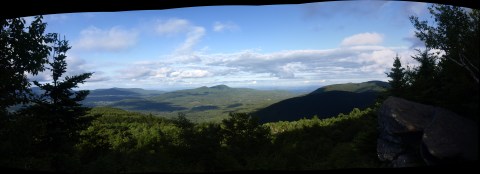
Panorama Reward
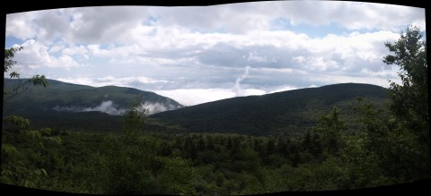
Panorama Reward
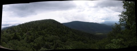
Panorama Reward

[…] “yes” was Kal and Silvia. I know Kal from my cycling, and this summer past we hiked The Devil’s Path in the Catskills, and though we didn’t talk about Winter camping then, the subject had since […]
[…] was finally ready to be picked up. Replacement transmission 😦 . Ouch! Anyway, when we hiked the Devil’s Path a few years back I was afraid to let Kal drive my truck, no matter how tired I was, and it […]